誌面連動企画
Haccho-daira: The quiet high moor in northern Kyoto

View of Haccho-daira from the southeastern section of the loop trail
Mountains in Kyoto / Kitayama
Haccho-daira: The quiet high moor in northern Kyoto
Text and photo; Takuya Minami (Editorial staff of Gakujin)
Mt. Minetokoyama 970m 6 hours 45 minutes
Katsuragawa-Nakamura~Nakamura-nokkoshi Pass~Ogurozaka Pass~Mt. Minetokoyama~Sanbon-sugi~Daihisan-guchi
Kyoto’s rare high moor
To the north of Kyoto City spreads a mountainous region known as Kitayama. The term generally refers to the range that stretches from the city’s outskirts toward the border with Fukui Prefecture, though some distinguish its southern half—commonly called the Rakuhoku area—as Kitayama, and its northern half as the Tamba Highlands. The mountains here rise to under 1,000 meters in elevation. Scattered settlements dot the mountainous areas, and thanks to limited but regular bus service, it is possible to link villages and mountains into a single journey on foot. I have visited this area several times myself. It was in the Taishō era that the members of Aoba-kai at the former Kyoto First Middle School—among them Kinji Imanishi and Eizaburō Nishibori—“discovered” Kitayama as a destination for mountaineering.
Within this range rises Mount Minetokoyama, the second highest peak in Kyoto Prefecture. From its summit, one can enjoy sweeping views of the Kitayama mountains, including the Hira Range and Mount Minago. To the east of Minetokoyama lies Haccho-daira, a rare high moor in Kyoto Prefecture—a place I had long hoped to visit.

 First photo: Kitayama-bushi seen along Egadani and at Haccho-daira
Second photo: Forest road along the Egadani stream from the bus stop
To Haccho-daira in the season of autumn
I boarded a Kyoto Bus from Demachiyanagi Station and headed to Katsuragawa-Nakamura, my starting point. From there, I followed a forest road that ran alongside the Egadani stream. The route itself was rather monotonous, yet the gentle murmuring of the stream, the clusters of Kitayama-bushi (a local species of monkshood), and the fungi sprouting along the path made the walk pleasant.
Where the valley forked in two, the road ended and the mountain trail began. The path narrowed, and I soon crossed a few small streams. Passing two giant boulders standing side by side, I left the valley behind and began the ascent toward Nakamura-nokkoshi Pass. The slope was steeper here, but the trail was well maintained and easy to walk. Fallen chestnuts scattered underfoot reminded me that autumn had already arrived. Feeling the cool breeze spilling over the pass, I soon reached the saddle of Nakamura-nokkoshi—open and refreshing.
Descending for about ten minutes, I joined the old Rokushaku-michi path. To the west stretched the wetland plateau of Haccho-daira. The vegetation was denser than I had imagined, yet when I followed the circular route and reached its southeastern side, the view opened suddenly to reveal the quiet, expansive wetland I had come to see.
The diversity of nature at Haccho-daira
Haccho-daira was formed about 30,000 years ago, when the valley on its southern side became dammed, trapping water and creating a wetland. In the past, the area was logged for firewood, and much of its current forest is secondary growth. Yet long-standing conservation efforts have helped safeguard its rich biodiversity and scenery. In 2016, Haccho-daira was designated as a Class I special zone within the Kyoto Tamba Kogen Quasi-National Park.
Walking along the boardwalks through the Buna (beech) and Mizunara (oak) forests, I stopped to look down and noticed clusters of Ōmizugoke (Sphagnum palustre) and Iwahime-warabi (a small fern)—names I later looked up. At first glance, the landscape might seem unremarkable, but over 150 species of plants inhabit this marsh. I could recognize only a few, yet as I lingered to observe the details, I felt something of the quiet complexity and abundance sustained here.

View of the Kitayama mountains stretching to the west from the summit of Mount Minetokoyama
A route steeped in history and culture
Returning to the Rokushaku-michi, I ascended gently until a small roadside shrine, enshrining a Jizō statue, appeared at the summit of Ogurozaka Pass. This old trail once served as a main route along the Saba Kaidō, the "Mackerel Road" that connected Obama in Fukui with Demachiyanagi in Kyoto, carrying fish and goods between the Sea of Japan and the ancient capital.
Taking the ridge on the western side of the pass, I crossed several small peaks before reaching the summit of Mount Minetokoyama. Although the sky was clouded, I could still make out the ridgelines of Mount Daihisan and the surrounding Kitayama mountains stretching away to the west. Beyond Tawara-zaka Pass, the trail descended in a zigzag toward the Teradani River, where it met a forest road once again.
On the way to the Daihisan-guchi bus stop, I made a short detour to see the Hanase Sanbon-sugi—the Three Cedars of Hanase. Of the three, one reaches 62.3 meters in height, recognized as Japan’s tallest tree. The path passes the gate of Bujo-ji Temple, which venerates these cedars as sacred trees. Founded in the late Heian period, this mountain temple uses Mount Daihisan behind it as its spiritual training ground. Even from outside the gate, the atmosphere felt distinct—filled with an austere, ancient presence. Though I wished to walk through the temple gate, access was closed that day, and with time running short, I reluctantly moved on. (The temple opens for a limited period in November for worship and viewing.)
I reached the bus stop twenty minutes before the final bus’s departure, grateful for a day spent quietly immersed in the natural and cultural layers of Kitayama.


First photo: Spacious Nakamura-nokkoshi Pass after ascending from the Egadani valley
Second photo: Ogurozaka Pass, where the ridge to Mount Minetokoyama begins near the Jizō statue
Third photo: Gentle streams encountered along the Haccho-daira loop trail
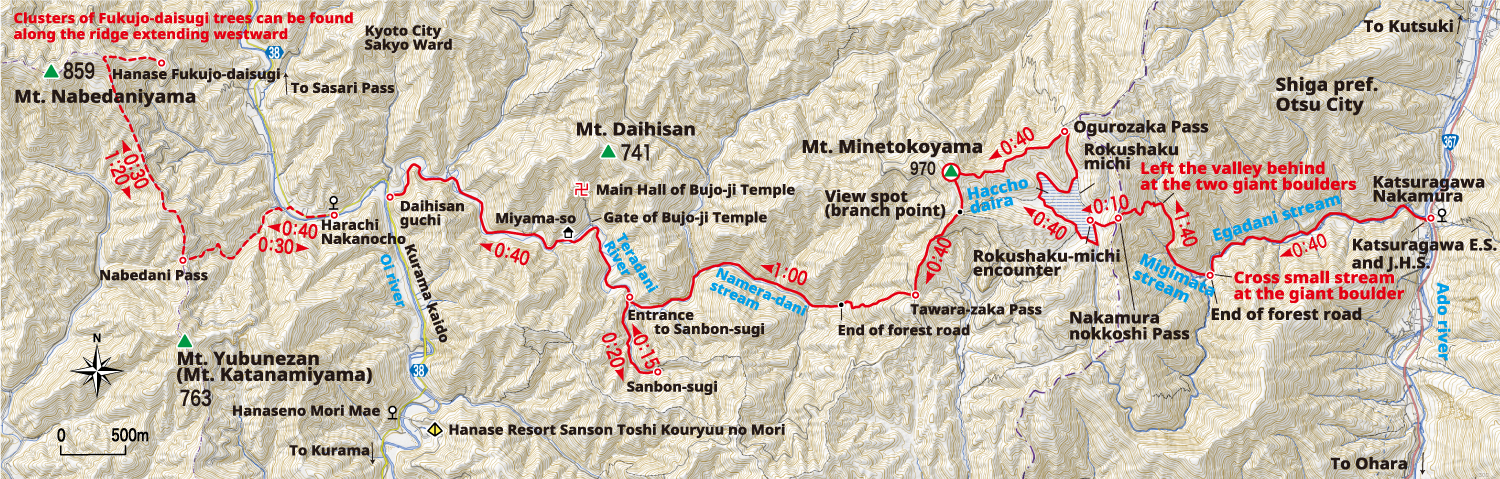
※Click to view detailed map.
[Hiking Level] Skill★☆☆☆☆ Fitness★★★☆☆
[DATA]
Access:[Heading] From Demachiyanagi Station of Keihan Ohto Line or Eizan line to Katsuragawa-Nakamura Bus stop (Kyoto Bus / 52 min), or from Katata Station of JR Kosei Line to Katsuragawa-Nakamura Bus stop (Kojaku Kotsu / 34 min). *Kyoto Bus; Weekends and holidays from March 16 to December 15, and August 14~16. [Return] From Daihisan-guchi bus stop to Demachiyanagi Station (Kyoto Bus / 1 h 40 min), heading time; 11:00 and 17:50.
Required Time:[Day trip]Katsuragawa-Nakamura (40 min) end of forest road (1h 40 min) Nakamura-nokkoshi Pass (10 min) Rokushaku-michi encounter (40 min) Ogurozaka Pass (40 min) Mt. Minetokoyama (40 min) Tawara-zaka Pass (1 h) Entrance to Sanbon-sugi (20 min) Sanbon-sugi (15 min) Entrance to Sanbon-sugi (40 min) Daihisan-guchi; Total 6 h 45 min.
Notes for Hikers:Leeches: Be cautious of yamabiru (mountain leeches) along the Egadani stream; use repellent spray.Bus schedule: The final bus departs at 17:50. The route requires ample time; be careful not to miss it.
Special Viewing of Bujo-ji Temple (November)
• Dates: November 2, 3, 15
• Admission: 2,000 yen
• Hours: 9:00–15:00 (last entry 14:30)
• Contents: Worship at the Main Hall / Viewing of the treasure storehouse displaying important cultural properties, including a statue of the Eleven-faced Thousand-armed Kannon and the Kongōrikishi guardians / Guidance on how to reach the Three Cedars (guided tour not available).
Note:
*From the Niōmon Gate onward to the Main Hall, mobile phones and cameras are prohibited.
*In the event of rain, worship at the Main Hall will be suspended.
*The temple gate is scheduled to be open on weekends in November (entry to the treasure storehouse is not permitted). As schedules may change, please confirm by phone in advance.


First photo: The towering Hanase Sanbon-sugi, standing closely together
Second photo: The gate of Bujo-ji Temple, visible from the road even when closed to the public
Nearby highlights around Mount Minetokoyama
 Hanase Fukujo-daisugi (a group of giant cedars):
Enormous cedars characterized by multiple curved trunks, bent under the heavy weight of snow, that took root again, and sprouted new stems. Clusters of these fascinating trees can be found along the ridge extending eastward from Mount Nabetaniyama.
 Hanase Resort Sanson Toshi Kouryuu no Mori
A 1,000-hectare forest park where visitors can enjoy camping, barbecues, and a café. It serves as an ideal base for hiking to Mount Minetokoyama or visiting the Three Cedars.
• Open 9:00–17:30 (Closed: Tuesdays (except July–August) / Year-end and New Year holidays)
• Admission: Free (check the park website for activity fees)
• Parking: 500 yen (1,000 yen in July–August)
Click here for the official website